Innovative techniques
TARI has developed the Agricultural Meteorology Information System (AMIS, http://amis.tari.gov.tw) to meet the farmers’ needs. Farmers can locate the weather station nearest their production sites through on-line interactive search map and obtain weather information and forecast pertinent to their locations to improve their farming management.
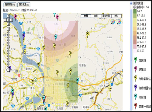
The weather information of this system is provided by the Central Weather Bureau. There are currently 534 automatic stations transferring data to the database system. Non-automatic stations are updated via regular manual downloads to ensure instant access to the most comprehensive weather data. The daily weather information in the database of 17 level 1 stations and 18 level 2 stations can be downloaded. AMIS provides the search function that offers compatible weather data at district level. The user can employ Google Maps to mark the location of the farmland and acquire real-time weather information through the geographic information system (GIS). For the prediction of hard-to-forecast weather-induced disasters, AMIS runs statistical analyses of long-term historical weather data to estimate the risks and probability of weather-induced disasters for establishing early warning and prevention measures.
Take orchard management for example, the orchard farmers can use AMIS to access weather information from the neighboring weather station. In case there are no weather stations nearby an orchard, the system will automatically turn to the nearest weather stations for weather information, and intersect the information with GIS to obtain weather information applicable to the orchard. Supported by the obtained current and forecasted weather information for the next seven weeks, the orchard farmers can properly manage irrigation, fertilization, spraying, bagging, and harvesting. Besides the interactive search for weather data, AMIS supplies customer-tailored weather tables on a regular time basis through membership. Also the system proactively announces early warnings if the probability of weather-induced disasters exceed certain critical levels. With the warnings, the orchard farmers can immediately set up preventive measures such as activating automatic sprinkler system to lower orchard temperature so as to reduce immature fruit drop and sunscald of fruit, and ensure fruit quality.
To serve the farmers, agricultural entrepreneurs and researchers, AMIS also provides query services on long-term weather trends in different regions, weather-induced disaster prevention technologies, converter of weather measurement units, the origin of 24 seasonal divisions, weather information in each of the 24 seasonal divisions, agriculture-related proverbs, and farmer’s almanac. AMIS is an open system responsive to the clientele and communities it serves.