Innovative techniques
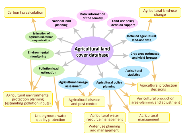
For past three years scientists at TARI have been using satellite imagery, aerial photography, and GIS (geographic information systems) mapping software to quantify type, spatial distribution and status of crops throughout the field in nine counties. The mapping information is also used for the assessment of environmental pollution and forecasting of crop yield, thus lays the ground for the development of precision agriculture. TARI also participates in the land use planning database group of Taiwan’s National Geographic Information System to provide the first hand information on crop production as related to climate change, natural disasters, and sustainable development. The information is integrated with other information such as water resource allocation, soil survey, meteorological phenomena, and soil and water conservation so that it can be available for query, analysis, management, planning and decision making.
As of the end of 2011, the satellite-image interpretation for rice, corn, sweet potato, alliums, peanut, carrot, sugarcane, pineapple and watermelon, and the aerial photographic interpretation for banana, guava, wax apple, papaya, mango, grape, carambola, tea plantation and bamboo grove have been carried out in nine counties.
There are many successful applications of map database. An example is the pollution fallout from an explosion on July 25, 2010 at Formosa Petrochemical Group's Naphtha Cracker No. 6 at Mailiao in Yunlin County and its impacts on garlic production in Yunlin County and the neighboring Changhua County. The analytical information is provided to the government for operation reference and the academia for research purpose.
Compared to traditional on-site surface survey, satellite imagery and aerial photography coupled with GIS mapping analysis proved to be cost effective and fast to cover large inaccessible area of rugged terrain for a long period of time. Being higher up in the air or atmosphere, however, means that both satellite imagery and aerial photography have adverse weather conditions to cope with. Research is being conducted to improve the techniques so they are not affected by adverse weather. In the future, efforts will also be made to develop the method for estimating large-scale crop production and the forecasting mechanism to avoid overproduction. Moreover, the interface with NGIS will be enhanced by providing the basic information for disaster risk management and climate change abatement as an integral part of the government's decision-making process related to national food security and sustainable agricultural development.